Coyote Creek Watershed Historical Ecology Study

Historical condition, Landscape change and restoration potential in the Eastern Santa Clara Valley, California
This report synthesizes historical evidence into a picture of how Coyote Creek looked and functioned before intensive modification. Prepared for the Santa Clara Valley Water District, the report helps explain contemporary landscape conditions and identify options for watershed restoration, natural flood protection, and integrated water management.
Download the Report
Download GIS Data
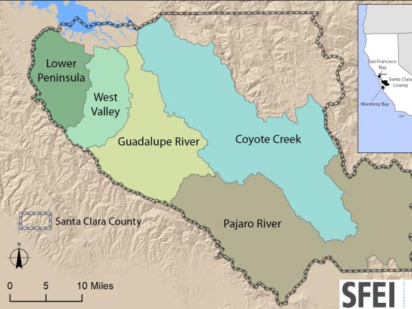
This dataset includes Santa Clara Valley and adjacent baylands
ESRI ArcMap 10 file geodatabase (.gdb) format
Historical Habitats, Channels and Distributaries
Dates:
2006
Funders:
Associated Staff:
Elise Brewster
Associated Data:
Programs and Focus Areas:
Resilient Landscapes Program
Historical Ecology
Watershed Science & Management
Related Projects, News, and Events:
 South Santa Clara Valley Historical Ecology Study (Project)
This study assesses historical conditions and landscape change in the southern part of the Santa Clara Valley. It is designed to inform strategies for natural flood protection, habitat conservation and restoration, and other management challenges.
 Western Santa Clara Valley Historical Ecology Study (Project)
This study produced GIS layers and a report describing historical habitats in the Guadalupe, West Valley, and Lower Peninsula Watershed Management Areas of Santa Clara County (the valley floor from Palo Alto to San Jose).
 Santa Clara Valley Water District Priority D5 Project's Watershed Condition Assessments (2010 to present) (Project)
https://www.valleywater.org/project-updates/2012-d5-ecological-data-collection-and-analysisSFEI and the Santa Clara Valley Water District's (Valley Water) Priority D-5 Project have been conducting baseline ecological condition assessments in Santa Clara County, CA to characterize the distribution and abundance of stream and wetlands in five major watersheds, and to assess the overall ecological conditions of streams in the watersheds based on the California Rapic Assessment Method for streams (CRAM). The surveys employ the state's recommended Wetland and Riparian Area Monitoring Plan's watershed aproach that includes the use of GIS-base maps of aquatice resources (BAARI), and spatially-balanced ambient stream condition surveys using CRAM.
 Coyote Creek Native Ecosystem Enhancement Tool (Project)
The Coyote Creek Native Ecosystem Enhancement Tool (CCNEET, neet. ecoatlas.org) is an online decision-support tool to identify opportunities to improve ecological conditions. CCNEET was inspired by the need for a watershed approach to environmental resource management. Available ecological and environmental information is synthesized by objectives, management questions, and enhancement actions to identify and justify potential habitat improvements along the creek corridor. The overarching goal of CCNEET is to help coordinate habitat conservation and enhancement along so that multiple projects and limited funding can result in meaningful ecological improvement.

 Upper Penitencia Creek: Historical Ecology Assessment (Project)
Upper Penitencia Creek, on the eastern side of Santa Clara Valley, has locally significant potential for stream restoration and anadromous fish recovery. The Upper Penitencia Creek Historical Ecology Assessment documents aspects of Upper Penitencia Creek's hydrogeomorphology and riparian ecology prior to major Euro-American modification. It describes the historical (ca. 1850) channel alignment, dry season hydrology, and riparian corridor of the creek as interpreted from early maps, textual records, and photographs.
The tidal-terrestrial transition zone (T-zone) occupies the gradient between the intertidal zone and terrestrial (i.e., levee faces, valleys, hillsides, alluvial fans, and bluffs) and/or fluvial (i.e., rivers and streams) environments. The T-zone provides a number of valuable ecosystem functions and services, and also serves as accommodation space for estuarine transgression and flood water dispersal/storage as sea level rises in the future.
 Urban Ecological Planning Guide for Santa Clara Valley (Project)
SFEI partnered with Santa Clara Valley Open Space Authority to create a guide on how to support biodiversity across the urbanized Santa Clara Valley. Urban greening projects (e.g., street trees, bioswales, gardens) are developing in piecemeal fashion. Designing and linking projects with ecology in mind can better support biodiversity, which in turn can help cultivate a sense of place and human health benefits.
 Upper Penitencia Creek: Resilient Landscape Vision (Project)
The San Francisco Estuary Institute-Aquatic Science Center and the Santa Clara Valley Water District worked with technical advisors and a group of local stakeholders to explore a range of multi-benefit management opportunities along Upper Penitencia Creek, culminating in this Resilient Landscape Vision. The vision focuses on ways to expand flow conveyance and flood water storage from the Coyote Creek confluence upstream to the Dorel Drive bridge in a manner that works with the existing landscape features and supports habitats for native species.
Western Santa Clara Valley Historical Ecology Study (Project)
This study produced GIS layers and a report describing historical habitats in the Guadalupe, West Valley, and Lower Peninsula Watershed Management Areas of Santa Clara County (the valley floor from Palo Alto to San Jose).