Santa Clara Valley historical ecology GIS
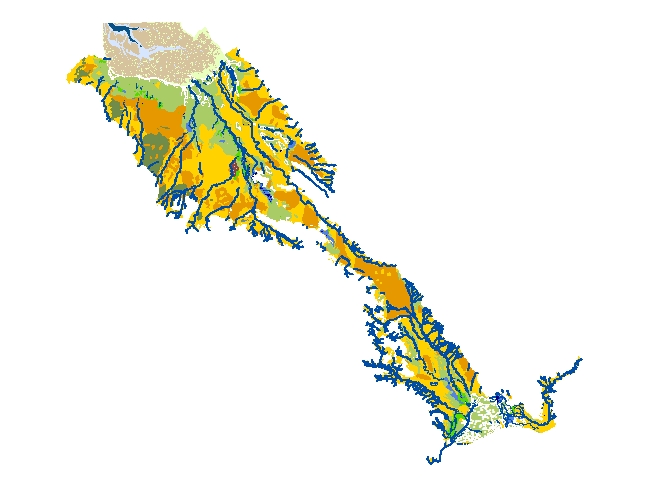
This dataset represents a reconstruction of the historical landscape patterns, including channel and habitat distribution, of the Santa Clara Valley and adjacent baylands. It integrates GIS data from 4 previous historical ecology studies including:
Coyote Creek Watershed (eastern Santa Clara Valley)
South Santa Clara Valley
Western Santa Clara Valley
T-Sheet mapping
Download GIS Data
ESRI ArcMap 10 file geodatabase (.gdb) format
Historical Habitats, Channels and Distributaries. (15.6 MB)
The Santa Clara Valley Water District's Watching Our Watersheds (WOW) project has adapted Historical Ecology data into Google Earth (KMZ) format. Adapted versions of SFEI's mapping of Santa Clara Valley are available for download:
- Southeast of San Francisquito Creek (Mountain View, Saratoga): Western Santa Clara Valley Historical (3 Mb)
- Guadalupe River and Coyote Creek (San José, Los Gatos): Central Santa Clara Valley Historical (3 Mb)
- South Santa Clara Valley (Morgan Hill, Gilroy): Southern Santa Clara Valley Historical (4 Mb)
Associated Data:
Programs and Focus Areas:
Resilient Landscapes Program
Historical Ecology
Related Projects, News, and Events:

The tidal-terrestrial transition zone (T-zone) occupies the gradient between the intertidal zone and terrestrial (i.e., levee faces, valleys, hillsides, alluvial fans, and bluffs) and/or fluvial (i.e., rivers and streams) environments. The T-zone provides a number of valuable ecosystem functions and services, and also serves as accommodation space for estuarine transgression and flood water dispersal/storage as sea level rises in the future.
 Urban Ecological Planning Guide for Santa Clara Valley published (News)
SFEI partnered with the Santa Clara Valley Open Space Authority to create a guide for how to support biodiversity across the urbanized landscape of Santa Clara Valley. Urban greening projects, such as street trees, green infrastructure, and backyard gardening, are already occurring piecemeal across urban areas. Harnessing this momentum can help these efforts build greater benefits for biodiversity.