Library
Our library features many hundreds of entries.
To search among them, click "Search" below to pull down options, including filtering by document type, author, year, and keyword.
Find these options under "Show only items where." Or you can also sort by author, title, type, and year clicking the headings below.
2023. North Bay Selenium 2019-20 QA Summaries. San Francisco Estuary Institute: Richmond, CA.
2021. Nature inequity and higher COVID-19 case rates in less green neighbourhoods in the United States. Nature Sustainability 4 (10).
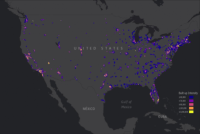 Urban nature—such as greenness and parks—can alleviate distress and provide space for safe recreation during the COVID-19 pandemic. However, nature is often less available in low-income populations and communities of colour—the same communities hardest hit by COVID-19. In analyses of two datasets, we quantified inequity in greenness and park proximity across all urbanized areas in the United States and linked greenness and park access to COVID-19 case rates for ZIP codes in 17 states. Areas with majority persons of colour had both higher case rates and less greenness. Furthermore, when controlling for sociodemographic variables, an increase of 0.1 in the Normalized Difference Vegetation Index was associated with a 4.1% decrease in COVID-19 incidence rates (95% confidence interval: 0.9–6.8%). Across the United States, block groups with lower-income and majority persons of colour are less green and have fewer parks. Our results demonstrate that the communities most impacted by COVID-19 also have the least nature nearby. Given that urban nature is associated with both human health and biodiversity, these results have far-reaching implications both during and beyond the pandemic.
Related data: https://www.sfei.org/data/nature-equity-covid-2021
2020. Neonicotinoids and Their Degradates in San Francisco Bay Water. SFEI Contribution No. 1002. San Francisco Estuary Institute: Richmond, CA.
In the summer of 2017, open Bay water samples were collected during the RMP Status and Trends Water Cruise. Samples were analyzed for 19 neonicotinoids and metabolites. The only neonicotinoid detected was imidacloprid, an active ingredient used in both urban and agricultural applications. Imidacloprid was detected at a single site above the method detection limits (2.2-2.6 ng/L) in Lower South Bay at a level of 4.2 ng/L. This value is within the range of concentrations found in a separate RMP study in water samples collected from the South and Lower South Bay margins in 2017. Imidacloprid was detected at 3 of 12 of the margin sites at levels between 3.9 and 11 ng/L; no other neonicotinoids were detected. Of note, these RMP studies appear to represent the first evaluation of ambient neonicotinoid concentrations in an estuarine environment in the nation.
2020. New Life for Eroding Shorelines: Beach and Marsh Edge Change in the San Francisco Estuary. SFEI Contribution No. 984.
2020. New San Francisco Bay Contaminants Emerge. SFEI Contribution No. 931. San Francisco Estuary Institute: Richmond, CA.
In 2016, the RMP launched a novel investigation to detect new or unexpected contaminants in Bay waters, as well as treated sewage (or wastewater) discharged to the Bay. This study used non-targeted analysis, a powerful tool that provides a broad, open-ended view of thousands of synthetic and naturally-derived chemicals simultaneously. We identified hundreds of contaminants, and the results have opened our eyes to urban stormwater runoff as an important pathway for emerging contaminants to enter the Bay.
2018. Non-Targeted Analysis of Water-Soluble Compounds Highlights Overlooked Contaminants and Pathways (Coming Soon). SFEI Contribution No. 905. San Francisco Estuary Institute: Richmond, CA.
2018. North Bay Mercury Biosentinel Project: 2016 - 2017. SFEI Contribution No. 868.
2018. North Bay Selenium Monitoring Design. SFEI Contribution No. 921. San Francisco Estuary Institute : Richmond, CA.
2017. Nutrient Management Strategy Science Program. SFEI Contribution No. 879. San Francisco Estuary Institute: Richmond, CA.
2016. Nutrient Management Strategy Science Plan Report. SFEI Contribution No. 878. San Francisco Estuary Institute: Richmond, CA.
2016. Nutrient Monitoring Planning Workshop - Summary of Existing Nutrient Monitoring Programs, Data Gaps, and Potential Delta RMP “No Regrets” Monitoring Activities. Aquatic Science Center: Richmond, CA.
This report was prepared as a briefing document for a September 2016 workshop held in Sacramento by the Delta Regional Monitoring Program. The purpose of the workshop was to plan how to invest in nutrients-related studies in order to inform better management of Delta waterways. First, the report compiles information about the major existing nutrient monitoring programs in the Sacramento-San Joaquin Delta. Next, it outline options for “no regrets” actions for workshop participants to review. The report summarizes interviews with representatives of Delta monitoring and resource management programs, describes current monitoring efforts in the Delta, and presents the conclusions and recommendations from recently completed data syntheses.
2015. Novato Creek Baylands Historical Ecology Study. SFEI Contribution No. 740. San Francisco Estuary Institute - Aquatic Science Center: Richmond, CA.
Project Background
Over the past century and a half, lower Novato Creek and the surrounding tidal wetlands have been heavily modified for flood control and land reclamation purposes. Levees were built in the tidal portion of the mainstem channel beginning in the late 1800s to convey flood flows out to San Pablo Bay more rapidly and to remove surrounding areas from inundation. Following levee construction, the wetlands surrounding the channel were drained and converted to agricultural, residential, and industrial areas. These changes have resulted in a considerable loss of wetland habitat, reduced sediment transport to marshes and the Bay, and an overall decreased resilience of the system to sea level rise.
In addition to tidal wetland modification, land use changes upstream in the Novato Creek watershed have resulted in several challenges for flood control management. Dam construction and increased runoff in the upper watershed have resulted in elevated rates of channel incision, which have increased transport of fine sediment from the upper watershed to lower Novato Creek. Channelization of tributaries and construction of irrigation ditches have likely increased drainage density in the upper watershed, also potentially contributing to increased rates of channel incision and fine sediment production (Collins 1998). Downstream, sediment transport capacity has been reduced by construction of a railroad crossing and loss of tidal prism and channel capacity associated with the diking of the surrounding marsh. As a result of the increased fine sediment supply from the watershed and the loss of sediment transport capacity in lower Novato Creek, sediment aggradation occurs within the channel, which in turn reduces the flood capacity of the channel, necessitating periodic dredging.
Currently, the Marin County Department of Public Works (MCDPW) is coordinating the Novato Watershed Program, which includes Marin County Flood Control and Water Conservation District, Novato Sanitary District, and North Marin Water District. Within lower Novato Creek, the Program is seeking to implement a new approach to flood control that includes redirecting sediment for beneficial use, reducing flood channel maintenance costs, restoring wetland habitat, and enhancing resilience to sea level rise. Included as part of this goal is the re-establishment of historical physical processes that existed before major channel modification, which in turn will re-establish historical ecological functions and help to create a tidal landscape that is resilient to increasing sea level.
2015. Novato Creek Baylands Vision: Integrating ecological functions and flood protection within a climate-resilient landscape. SFEI Contribution No. 764.
This report explores the potential for integrating ecological functions into flood risk management on lower Novato Creek. It presents an initial vision of how ecological elements could contribute to flood protection, based on a broad scale analysis and a one day workshop of local and regional experts. The Vision is not intended to be implemented as is, but rather adapted and applied through future projects and analysis. Other actions (e.g., floodwater detention basins) may also need to be implemented in the interim to meet flood risk objectives.
2014. Natural Flow Hydrodynamic Modeling Technology Support Phase 1 Technical Memorandum.
This technical memorandum summarizes the work to date carried out by the San Francisco Estuary Institute (SFEI) to generate a bathymetric-topographic digital elevation model (DEM) of the historical Sacramento-San Joaquin Delta (representative of early 1800s conditions). The historical DEM described in this document is an interim/draft product completed for Phase I of the Bay-Delta Natural Flow Hydrodynamics and Salinity Transport modeling project. It is expected that the product and methods described here will be refined during a second phase of the project.
2014. Newcomb Avenue Green Street (Case Study Site and Technical Reports). SFEI Contribution No. 793.
2014. North Bay Mercury Biosentinel Project (December 2014 Report). SFEI Contribution No. 738. San Francisco Estuary Institute: Richmond, CA.
2014. Northern San Diego County Lagoons Historical Ecology Investigation. SFEI Contribution No. 722. San Francisco Estuary Institute - Aquatic Science Center: Richmond, CA. p 215.
2014. Nutrient Moored Sensor Program: Year 1 Progress Update. SFEI: Richmond, CA.
2014. Nutrient Stormwater Monitoring Results: WY2012 and WY2013. San Francisco Estuary Institute: Richmond, CA.
2012. Napa River Watershed Profile: Past and Present Characteristics with Implications for Future Management of the Changing Napa River Valley. San Francisco Estuary Institute: Richmond, CA. p 172.
2012. Napa Valley Historical Ecology Atlas: Exploring a Hidden Landscape of Transformation and Resilience. UC Press: Berkeley. p 223.
2012. Non-targeted analysis update.
2008. Napa Watershed Symposium.
2002. Napa River Sediment TMDL Baseline Study: Geomorphic Processes and Habitat form and function in Soda Creek. SFEI Contribution No. 63. San Francisco Estuary Institute: Oakland, CA.
1995. Nonindigenous Aquatic Species in a United States Estuary: A Case Study of the Biological Invasions of the San Francisco Bay and Delta. U. S. Fish and Wildlife Service: Washington DC.
1989. New Justifications for Traditional Types of Water Projects, University of California: Berkeley, CA.
1987. Natural and artificial wetland ecosystems - ecological opportunities and limitations. In Aquatic Plants for Water Treatment and Resource Recovery. . Aquatic Plants for Water Treatment and Resource Recovery. University of Florida: Gainesville, FL.