Using Drones to Improve Corte Madera Marsh Management
Sep 27, 2018
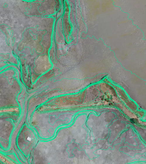
SFEI is increasing the use of drones to support assessing and monitoring the health of local ecosystems. We recently completed UAS (Unmanned Aerial Systems), or drone, flights over Corte Madera marsh. This effort will improve marsh management by studying marsh erosion processes and detecting changes in the marsh edge due to marsh growth or attrition from winter storms.
This is the second time that SFEI has surveyed Corte Madera marsh’s edge, but this times comes with significant improvements.
This UAS survey was conducted in lieu of a more costly LiDAR mapping effort, while providing survey grade accuracy elevation data in addition to high resolution imagery. During this survey, 12 ground control point markers were placed along the levees and located spatially using a high-precision GPS. The ground control points helped to produce a Digital Elevation Model (DEM) with sub-centimeter accuracy, along with ¼-Inch-resolution orthoimagery that has been carefully georeferenced.
SFEI is finding an increased interest by our partners in our drone technology. They may also be used in order to train models to detect trash in natural environments, support restoration planning efforts, and perform detailed vegetation monitoring and mapping.
SFEI is now able to produce these high-quality products with significantly less time and effort to support projects addressing issues such as erosion pattern analysis, restoration monitoring, sediment transport analysis, local vegetation mapping, trash assessments, and others.
Contact [email protected] for any information on our services and projects.
Associated Staff:
Programs and Focus Areas:
Environmental Informatics Program
Resilient Landscapes Program
Related Projects, News, and Events:
 Vision from the Skies: Using UAS Surveys to Monitor a Key Restoration Project (News)
At the McCosker Creek Restoration site, 3,000 linear feet of creek channel that previously had been flowing through underground culverts since the 1950s was daylighted and reconstructed. In addition, invasive and non native plants were removed and replaced with over 5,000 native plants. The restoration was also designed to support erosion control, and provide habitat for wildlife and aquatic species including rainbow trout, California red-legged frog and the Alameda whipsnake. This restoration work began in 2020 and concluded in 2023.