Tony Hale

Tony Hale, PhD
Program Director
Environmental Informatics Program
Design and Communications
Geographic Information Systems
Information Technology Systems
510-746-7381
Dr. Tony Hale worked in a range of corporate and educational organizations, as well as both private nonprofit and public institutions, before establishing himself as an environmental science technologist. As Program Director for Environmental Informatics, Dr. Hale represents five technical teams: Geographic Information Systems, Application Development, Data Services, IT Systems, and Design & Communications. He always pursues compelling ways to promote technology initiatives, environmental stewardship, and meaningful, collaborative innovations.
While completing his doctorate at UC Berkeley, Dr. Hale consulted in technology for several years before launching a career at Mills College where he eventually served four years as an IT Director. He then progressed to become head of the enterprise applications team for Peralta Community College District, the second-largest educational organization in the San Francisco Bay Area.
Making the transition to environmental science, Dr. Hale joined the California Ocean Science Trust and led the development of OceanSpaces, an online community to foster new knowledge of ocean health. He also served as member of several state-level committees including the California Coastal & Marine Geospatial Workgroup. He is currently co-chair of the Data Management Workgroup, affiliated with the California Water Quality Monitoring Council.
With SFEI, Dr. Hale has advanced the Institute’s communications practices, overseen the development of new data visualization technologies, and partnered with state and federal agencies to address complex data management challenges.
Related Projects, News, and Events
 Advancing Performance Measures (Project)
This project consists of an effort to enhance EcoAtlas to serve as the shared and primary point of collection for project data, then actively transfer the data to Delta View.
 Habitat Restoration Project Tracking (Project)
This project expands the current capabilities of the wetland project tracking system for the monitoring and assessment of California’s aquatic resources to meet the project tracking, assessment, and reporting needs for current and planned habitat restoration in the San Francisco Bay-Delta and Central Valley.
Working in partnership primarily with the City of Richmond and the County of Contra Costa County, SFEI is developing a new GreenPlan-IT Tracker. The new tool comprises another module within the GreenPlan-IT Toolbox which, along with its three other modules, helps to plan, assess, optimize, and track municipal efforts to reduce stormwater run-off and reduce pollutant loads to the Bay.
 Lahontan Water Board adopts Regional EcoAtlas Tools (News)
The Lahontan Water Board (Regional Water Board 6) has formally adopted EcoAtlas and the California Rapid Assessment Method (CRAM). This will enable the Water Board to visually track and assess the extent of project impacts on a watershed basis throughout the region.
Beginning August 1 of this year, 401 Certifications and Waste Discharge Requirements will require applicants to upload project information into EcoAtlas. Applicants will be encouraged to use CRAM in pre- and post- project assessments.
 Enhancing the Vision for Managing California’s Environmental Information (Project)
SFEI's Tony Hale helped to lead a collaborative effort to advance California's management of its environmental data and derived information. This white paper is a synthesis of ideas explored during the Data Summit (June 2014) based on initiatives, current programs and the experiences of individuals from State and federal agencies, academia, private and non-governmental entities.
 Tony Hale will be speaking at the State Water Board's "Data Fair" (Event)
From the State Water Resources Control Board: The Water Board's Office of Information Management and Analysis (OIMA) will host a data fair aimed at providing a forum to enhance the availability and integration of the Water Board's key datasets. The format will be a combination of thought-provoking presentations and access to dataset stewards. Some of the presentations will highlight projects and concepts to synthesize water resource related data. Others will lay out elements of the Water Boards' strategy to increase the availability and usefulness of our vast water resource related data and information.
 SFEI provides perspective on emerging harmful bacterial blooms in the State's larger waterbodies (News)
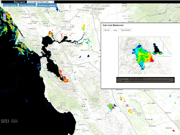
The State has contracted SFEI to provide intellectual, scientific, and technical resources to support its efforts to monitor and report on the ever-growing problem of cyanobacterial blooms in its lakes and rivers. These blooms are such a serious concern because they can generate harmful toxins which can threaten wildlife, livestock, pets, and in certain cases, human life.
 Enhancing the Vision for Managing California's Environmental Information (News)
Under the aegis of the Delta Stewardship Council, SFEI helped usher forth a vision document with recommendations for enhancements to California's information technology infrastructure and associated practices. Called "Enhancing the Vision for Managing California's Environmental Information," the white paper was highly collaborative, with a team of writers contributing their ideas from private industry, non-profits, and various state agencies. Dr. Tony Hale, SFEI's Program Director for Environmental Informatics, served as the white paper's chief editor.
 RMP Annual Meeting Summarized on Twitter (Event)
The RMP Annual Meeting was held in conjunction this year with the State of the Estuary Conference. Collectively, the events brought together over 800 people interested in the condition of our estuary.
Below is featured a collection of highlights of the conference as recorded in social media in the form of videos, images, quotations, and other observations. We hope you enjoy perusing this unique conversation of over 89 users, 500 tweets, and a world-wide audience of over 400,000 people.
 The launch of the SF Bay Nutrients Visualization Tool (News)
This visualization tool facilitates intuitive comparison of continuous data from around the Bay, and across a variety of analytes, to demonstrate the potential for collaborative monitoring across programs.
 Web Services Available for CRAM and Wetland Projects (News)
Web services provide a standard way to access geo-referenced data online. SFEI now provides web services for the California Rapid Assessment Method (CRAM) Assessment Areas and California Wetland Projects data layers.Although potential uses are numerous, typically web services allow one machine to exchange data with another for timely, automated, and efficient sharing of information. Different service types provide different levels of access to the data, including serving image tiles of the data or the features and attributes themselves.
- ‹ previous
- 4 of 4